Log in
All resources
Create a design
1,097 Free Artworks of Coats Of Arms On Maps
bibliothèque nationale de france
remigius parr
john rocque
john rocque's 1748 map of london and adjacent country
maps in the rijksmuseum amsterdam
maps by thomas kitchin
thomas kitchin
maps by willem and johannes blaeu
maps of limburg by aegidius martini
john rocque's 1746 map of london
carte des environs de paris (1678)
bibliothèque nationale de france
17th-century maps of the strait of magellan
1640 maps of south america
maps of eckernförde by braun & hogenberg
bibliothèque nationale de france
maps of orléans by braun & hogenberg
bibliothèque nationale de france
maps of limburg by aegidius martini
bibliothèque nationale de france
maps of limburg by aegidius martini
bibliothèque nationale de france
maps of bergen op zoom by braun & hogenberg
bibliothèque nationale de france
maps of paris by braun & hogenberg
bibliothèque nationale de france
maps of limburg by aegidius martini
bibliothèque nationale de france
maps of exeter by braun & hogenberg
bibliothèque nationale de france
magni ducatus lithuaniae
1710s maps of lithuania
maps of london by braun & hogenberg
bibliothèque nationale de france
maps of limburg by aegidius martini
bibliothèque nationale de france
john rocque's 1748 map of london and adjacent country
remigius parr
john rocque's 1748 map of london and adjacent country
remigius parr
john rocque's 1748 map of london and adjacent country
remigius parr
john rocque's 1748 map of london and adjacent country
remigius parr
john rocque's 1748 map of london and adjacent country
remigius parr
john rocque's 1748 map of london and adjacent country
remigius parr
john rocque's 1748 map of london and adjacent country
remigius parr
john rocque's 1746 map of london
remigius parr
john rocque's 1748 map of london and adjacent country
remigius parr
john rocque's 1746 map of london
remigius parr
john rocque's 1748 map of london and adjacent country
remigius parr
john rocque's 1748 map of london and adjacent country
remigius parr
utrecht (city) in the 17th century
joost cornelisz. droochsloot
etchings in the rijksmuseum amsterdam
history of rotterdam
maps of chester by braun & hogenberg
bibliothèque nationale de france
maps of besançon by braun & hogenberg
bibliothèque nationale de france
maps of portugal by fernando álvares seco
bibliothèque nationale de france
john rocque's 1748 map of london and adjacent country
remigius parr
john rocque's 1746 map of london
remigius parr
john rocque's 1748 map of london and adjacent country
remigius parr
john rocque's 1748 map of london and adjacent country
remigius parr
john rocque's 1748 map of london and adjacent country
remigius parr
john rocque's 1748 map of london and adjacent country
remigius parr
john rocque's 1748 map of london and adjacent country
remigius parr
maps of the universiteit van franeker
maps in the rijksmuseum amsterdam
drawings by cornelis troost in the rijksmuseum amsterdam
rococo
1630s maps of the iberian peninsula
hessel gerritsz
bibliothèque nationale de france
maps by thomas kitchin
18th-century maps of cornwall
maps by thomas kitchin
bibliothèque nationale de france
maps by thomas kitchin
maps by thomas kitchin
old maps of hampshire
maps in the rijksmuseum amsterdam
old maps of franeker
old maps of oxfordshire
maps by thomas kitchin
prints by pieter van den berge in the rijksmuseum amsterdam
maps in the rijksmuseum amsterdam
prints by pieter van den berge in the rijksmuseum amsterdam
maps in the rijksmuseum amsterdam
1770s maps of rhineland-palatinate
maps of east palatinate by sanson
lionnois, forest, beauiolois et masconnois (old maps)
maps by willem and johannes blaeu
sanson maps of south america
louis cordier
mappe-monde geo-hydrographique (sanson and jaillot, 1674)
louis cordier
djvu files in spanish about argentina
argentina y sus grandezas (1910)
djvu files in spanish about argentina
argentina y sus grandezas (1910)
mappe-monde geo-hydrographique (sanson and jaillot, 1674)
louis cordier
carte des pays-bas catholiques by guillaume sanson
robert cordier (engraver)
bibliothèque nationale de france
cartouches by tomas lópez
bibliothèque nationale de france
guillaume sanson
carte de moscovie by guillaume de l'isle (1706)
bibliothèque nationale de france
carte de moscovie by guillaume de l'isle (1706)
bibliothèque nationale de france
carte de la province de berry (1707) by jaillot
bibliothèque nationale de france
carte des pays-bas catholiques by guillaume sanson
robert cordier (engraver)
carte de moscovie by guillaume de l'isle (1706)
bibliothèque nationale de france
18th-century portrait paintings in the national maritime museum, london
john francis rigaud
civitates orbis terrarum. contrafactur und beschreibung von den vornembsten stetten der welt. liber tertius
maps of philippeville by braun & hogenberg
civitates orbis terrarum. contrafactur und beschreibung von den vornembsten stetten der welt. liber tertius
maps of arnhem by braun & hogenberg
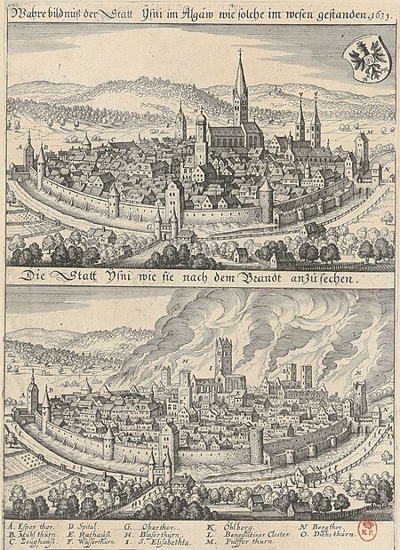
1631 stadtbrand von isny im allgäu
baroque
old maps of berbice
hendrik de leth
19th-century maps of groningen (province)
old maps of groningen (city)
maps of the iberian peninsula by mercator-hondius
maps by pieter van der keere
civitates orbis terrarum. contrafactur und beschreibung von den vornembsten stetten der welt. liber tertius
maps of fortress of charlemont by braun & hogenberg
maps of aalst by braun & hogenberg
peter von brachel
maps of rügen by eilhard lubinus
bibliothèque nationale de france
maps of dordrecht by braun & hogenberg
bibliothèque nationale de france
maps of bamberg by braun & hogenberg
bibliothèque nationale de france
a map of the british empire in america with the french and spanish settlements adjacent thereto
bibliothèque nationale de france
territorium argentoratense (1652 map)
bibliothèque nationale de france
maps of huy by braun & hogenberg
bibliothèque nationale de france
17th-century maps of pembrokeshire
maps by jodocus hondius ii
old maps of regensburg
baroque
maps of the universiteit van franeker
maps in the rijksmuseum amsterdam
maps by isaak tirion
old maps of haarlem
le royaume de france distingué by guillaume sanson
1708 maps of france
sanson maps of the circles of germany
bibliothèque nationale de france
bibliothèque nationale de france
guillaume sanson
maps by willem and johannes blaeu
wachtendonk in the 1650s
dutch 18th-century drawings in the rijksmuseum amsterdam
gerrit de broen jr. (1692-1774)
maps of switzerland by johann jakob scheuchzer
maps in the rijksmuseum amsterdam
maps of switzerland by johann jakob scheuchzer
maps in the rijksmuseum amsterdam
old maps of groningen (city)
egbert haubois
prints by wenceslaus hollar in the rijksmuseum amsterdam
maps by wenzel hollar
context files from gallica
history of rügen
magni ducatus lithuaniae
radziwiłł (surname)
maps of switzerland by johann jakob scheuchzer
maps in the rijksmuseum amsterdam
city walls of vienna
views of vienna
maps of provence by pierre-jean de bompar
bibliothèque nationale de france
maps of béthune by braun & hogenberg
bibliothèque nationale de france
maps of munich by joris hoefnagel
bibliothèque nationale de france
maps of béthune by braun & hogenberg
bibliothèque nationale de france
media from regionaal archief alkmaar
geestmerambacht
701 - 800 of 1,097
Next page
/ 11


![Huum opp. Condrusorum Caput [...] Anno partae salutis. M. D. LXXIIII., between 1574 and 1640](https://cdn.creazilla.com/illustrations/10001498653/huum-opp-condrusorum-caput-anno-partae-salutis-m-d-lxxiiii-between-1574-and-1640-md.jpg)


